NISAR Explained: How NASA and ISRO Are Advancing Earth Science
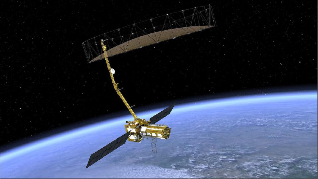
NASA and the Indian Space Research Organisation (ISRO) are gearing up for the launch of the NISAR (NASA-ISRO Synthetic Aperture Radar) mission, a ground breaking initiative poised to transform the way scientists study and monitor Earth’s complex systems. Targeting an early 2025 launch from India, NISAR will be the world’s most advanced dual-frequency radar imaging satellite, merging the expertise of two major space agencies to address some of the planet’s most pressing challenges.
The Mission’s Unique Technology
The NISAR satellite stands out due to its unique combination of L-band and S-band synthetic aperture radar (SAR) technologies. Where Synthetic aperture radar (SAR) refers to a technique for producing fine-resolution images from a resolution-limited radar system. It requires that the radar be moving in a straight line, either on an airplane or, as in the case of NISAR, orbiting in space. These radar systems allow the satellite to penetrate cloud cover and darkness, providing high-resolution, all-weather imaging capabilities. The dual-band approach will enable NISAR to monitor changes in Earth’s land, ice, and vegetation with unprecedented accuracy.
The satellite will be capable of detecting subtle shifts in the Earth’s surface, down to a few millimeters, allowing scientists to track a wide range of geophysical phenomena, from glacier movement and ice sheet melting to forest growth and soil moisture changes.
Applications for Global Challenges
The primary goal of the NISAR mission is to provide consistent, high-resolution data to help scientists better understand and address global issues such as climate change, deforestation, and natural disasters. By providing detailed and frequent observations of Earth’s dynamic processes, NISAR is expected to be an invaluable tool for researchers and policymakers around the world.
Dr. Anjali Verma, an environmental scientist specializing in climate change, noted, “NISAR is set to become a cornerstone in our efforts to combat and adapt to the effects of climate change. The data it will provide can help governments and organizations make informed decisions to safeguard vulnerable communities and ecosystems.”
Monitoring Disasters and Resource Management
One of the most significant impacts of the NISAR mission will be its role in disaster management. The satellite will monitor seismic activity, enabling the early detection of potential earthquakes and landslides. This can provide critical insights for disaster preparedness and response, potentially saving lives and minimizing damage.
Additionally, NISAR’s data will aid in water resource management and agriculture by providing precise information on soil moisture levels. This can help improve crop yield predictions and water use efficiency, supporting sustainable agriculture practices.
A Symbol of International collaboration
On Sept. 30, 2014, NASA and ISRO signed a partnership to collaborate on and launch NISAR. The mission was targeted to launch in 2024 but now it’s expected an early 2025 launch from Sriharikota in India. NASA is providing the mission’s L-band synthetic aperture radar, a high-rate communication subsystem for science data, GPS receivers, a solid-state recorder and payload data subsystem. ISRO is providing the spacecraft bus, the S-band radar, the launch vehicle and associated launch services. The NISAR mission is not only a technological marvel but also a symbol of international cooperation.
Dr. Ramesh Rao, a senior engineer at ISRO, emphasized the importance of this partnership: “The collaboration between NASA and ISRO on the NISAR mission showcases how space exploration can transcend borders. Together, we’re leveraging our collective expertise to benefit humanity.
The Road to Launch
As the launch date approaches, final preparations are underway to integrate the satellite with its launch vehicle. Scientists and engineers from both agencies are running extensive tests to ensure the satellite’s systems will function flawlessly in orbit.
With NISAR set to provide a wealth of data on Earth’s changing landscape, scientists anticipate it will open new avenues for research and create opportunities for global collaboration. The mission’s success could mark the beginning of a new era in satellite-based Earth observation, reshaping how we monitor and respond to the evolving challenges our planet faces